

Le radar mural : un nouvel outil pour l'archéologue du bâti
Résumé
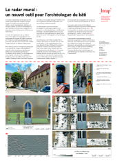
New tools such as photogrammetry or 3D scanner surveys have revolutionized the way of understanding the archaeological study of a building. These tools are now commonly used but, when the walls of a building are covered by a plaster, the visual observations are considerably more complex. The implantation of observation windows to be pitted can prove to be a delicate exercise and potentially not representative of the part of the building to be studied. Geophysical techniques and more particularly the radar method can partly guide this approach thanks to the preliminary realization of an extensive wall imaging. They can also be a precious help for the setting up of scientific projects of building excavations by giving an overview of the surfaces not probed during the diagnosis. This type of analysis is based on the use of very high frequency radar (>2 GHz). These radar antennas, initially developed for civil engineering, allow the inspection of concrete and the evaluation of its quality. When the surface of a wall is sufficiently smooth, the realization of a dense mesh of measurement allows very quickly to auscultate the wall on a few decimeters of thickness with a very high resolution. Old features can then appear such as blocked openings or differences in blocking. These themes are still very little developed but a strong potential exists. Inrap’s geophysics and remote sensing unit is currently working on this theme to improve building studies. Following a first test carried out at the Abbey of Ferrières-en-Gâtinais (45), we will show here the potential of the method and the various applications which can result from it to help the work of the archaeologist of the building. A PAS research project has been submitted in 2021 to associate geophysicists and archaeologists on this research theme directly related to the operational.
Les nouveaux outils tels que la photogrammétrie ou les relevés scanner 3D ont révolutionné la façon d’appréhender l’étude archéologique d’un édifice. Ces outils sont désormais couramment utilisés mais, lorsque les parois d’un édifice sont recouvertes par un enduit, les observations visuelles sont rendues considérablement plus complexes. L’implantation des fenêtres d’observation à piqueter peut s’avérer être un exercice délicat et potentiellement non représentative de la partie de l’édifice à étudier. Les techniques géophysiques et plus particulièrement la méthode radar peuvent en partie guider cette démarche grâce à la réalisation préalable d’une imagerie murale extensive. Elles peuvent également être une aide précieuse pour le montage des projets scientifiques d’intervention de fouilles de bâti en donnant un aperçu des surfaces non sondées lors du diagnostic. Ce type d’analyse repose sur l’emploi de radar à très haute fréquence (>2 GHz). Ces antennes radar, initialement développées pour le génie civil, permettent l’auscultation des bétons et l’évaluation de leur qualité. Lorsque la surface d’un mur est suffisamment lisse, la réalisation d’un maillage dense de mesure permet très rapidement d’ausculter le mur sur quelques décimètres d’épaisseur avec une très haute résolution. Des aménagements anciens peuvent alors apparaître tels que des ouvertures colmatées ou des différences de blocage. Ces thématiques sont encore très peu développées mais un potentiel fort existe. La cellule géophysique et télédétection de l’Inrap travaille actuellement sur cette thématique destinée à améliorer les études de bâti. Suite à un premier test réalisé à l’abbaye de Ferrières-en-Gâtinais (45), nous montrerons ici le potentiel de la méthode et les différentes applications qui peuvent en découler pour aider le travail de l’archéologue du bâti. Un projet de recherche PAS a été déposé en 2021 pour associer géophysiciens et archéologues sur cette thématique de recherche en lien direct avec l’opérationnel.
Fichier principal
 2021_POSTER_Hulin_et_al_Radar_mural_SST5_Inrap.pdf (14.13 Mo)
Télécharger le fichier
2021_POSTER_Hulin_et_al_Radar_mural_SST5_Inrap.pdf (14.13 Mo)
Télécharger le fichier
Origine : Fichiers produits par l'(les) auteur(s)


